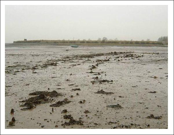
Ancient wooden posts in the Creek
There are many pieces of
ancient wood projecting out of the mud in middle of the Creek, on the north
side about 100yds east of the remains of the wreck of barge Snowdrop...
|
|||||||||
|
|
|||||||||
|
There has been much speculation
in the past as to the origins of these posts: o Fishing weirs or Kettles
used to catch shoals fish See... fishing in the
Estuary o An earlier wooden
abatement or seawall that took a different path to the present walls. See... Seawall construction o Part of a tide mill or
water mill that has been referred to as being near Goldhanger in the past.
See... Watermill at Goldhanger o Part of an enclosure that
made the creek into a harbour (there are also many stones lying in this area) o A pier used
by the Roman o A jetty used
by the village fishing fleet in the 18th &19th centuries. See... fishing in the Estuary Today it seems that one,
or both, of the two later alternatives above are the most likely, as much
more evidence has come to light over the years... |
|||||||||
|
In 1910 a report of
excavation work on Redhills by Francis Reader,
undertaken in Bounds Farm at the edge of the
Creek included a map which showed a Pile
Foundation in the middle of the Creek... It was also referred to in
the text of the report...
This square arrangement of
posts is unlikely to have been a fishing weir. |
|
||||||||
|
|
|
||||||||
|
|
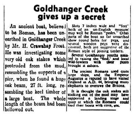
Goldhanger's notable
character and amateur historian Crawshay Frost
investigated the posts in the 1940s and this article appeared in a local newspaper
in 1947. He was clearly convinced he had found the remains of a jetty and
large ancient boat. We know that Frost
employed many young men to build a barrage to drain the water and clear the mud
from around the piles to access the boat remains, so he is likely to have
disturbered and maybe destroyed the rectangular
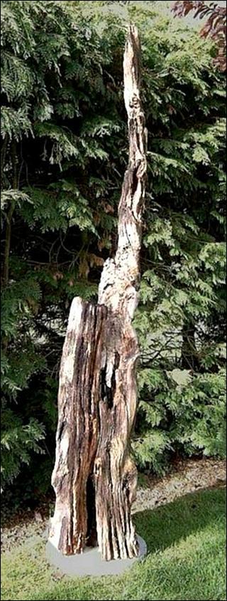
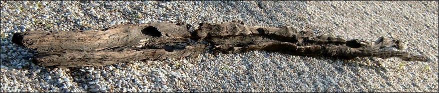
form described in the 1910 report. A piece of that Ship's keel is still in the village... |
||||||||
|
the “keel” over Mr Frost’s driveway in the 1950s |
the “keel” in another garden in more recent times |
||||||||
|
the “keel” as it was when retreived for Frost’s Fish
St back garden in 2007ish it was moved with the kind permission of Mick West the property owner at the time it was then about 3m long and clearly slowly
decaying At that time Colchester Museum
was contacted with a view to asking if they thought the piece of wood was
likely to be from the Roman period. However, their expert’s initial response
was “it should never have been taken out of the Creek”! Having explained the
the person who did that had been dead for 40 years, the expert declined to
give any opinion as to its age and said they would not be interested in
acquiring it. When asked the best way to preserve it, the response was “burn
it”. |
|||||||||
|
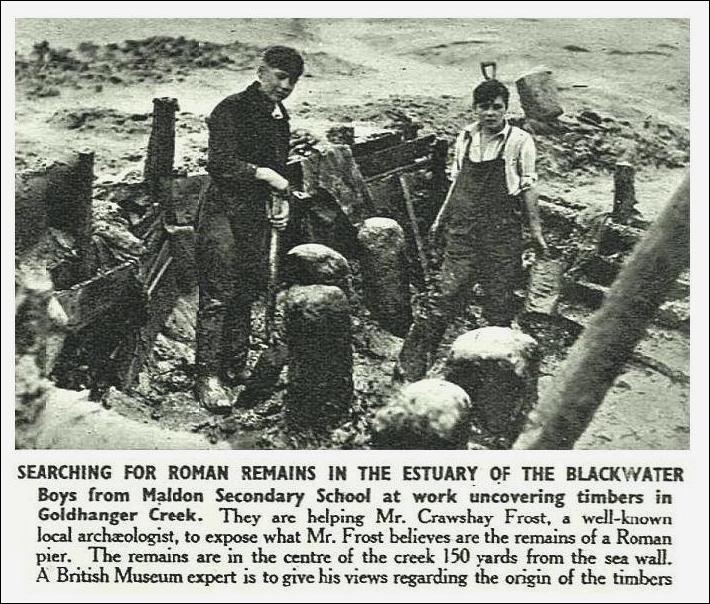
This amazing photograph and
caption appeared in 1947 in the London based magazine called The Sphere. Crawshay Frost probably
took the photograph. One can only wonder if these
substantial posts are still there under the mud in the Creek. |
|
||||||||
|
|
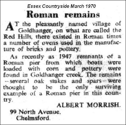
In 1970 this letter was
published in the Essex Countryside magazine. Little is known about Mr Morrish
other than that he wrote descriptions of 200 churches in the Diocese of
Chelmsford in the 1940s, some of which were printed in that same magazine, so
he was clearly an Essex historian of some note. It refers to 1947, the
year in which Mr Frost declared the find. |
||||||||
|
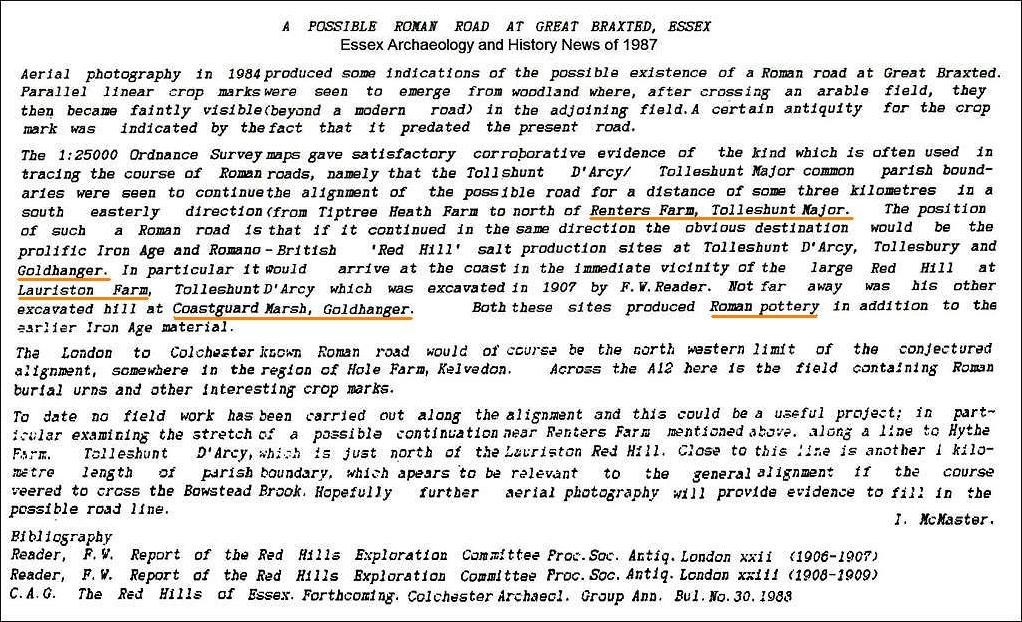
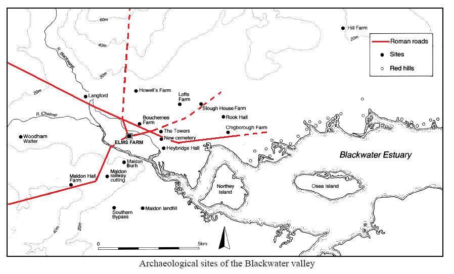
This 1987 paper
identifies a potential Roman Road from the Colchester to London road at Kelvedon
travelling to the coast and the Red Hills / salt works at Lauriston Farm and
Bounds Farm, Goldhanger...
|
|||||||||
|
In 1991 samples of wood
from the Creek were radiocarbon dated by the Isotope Measurements Laboratory
at Harwell and found to be of 13th century origin. [Radiocarbon,
Vol 33, No. 1, 1991, P 87-113] |
|||||||||
|
Here are extracts from a thesis submitted
to the University of Nottingham in July 2013... Transformations of Identity
and Society in Essex, c.AD 400-1066 by Alexander Mirrington available at... eprints.nottingham.ac.uk/Transformations_of_Identity_and_Society_in_Essex_c.AD_400-1066_Vol.I.pdf |
|||||||||
|
This
study examines the archaeological reflections of group identity and
socioeconomic networks in the region of Essex and London in the Anglo-Saxon
period, between c.400 and 1066. Given its location in the south-east of
England, Essex was a key zone of socio-political interaction during the early
medieval period. ...In
the later 9th/10th –century, the pottery record may
also testify to the emergence of a trading
centre at Maldon ... The
town would have attracted trade up the Blackwater Estuary, and probably
facilitated great onward movement on radiating inland routeways – perhaps
Roman roads emanating from Roman settlement in the Maldon area. ...
As a royal mint in 925, it is clear
that Maldon rapidly grew in importance following the West Saxon
reconquest. The products of its mint
have not been found in Maldon, but are relatively common in Scandinavia. ...Stephen
Rippon* has perhaps
provided the greatest individual contribution our understanding of the later
Saxon Essex...Rippon‟s work on coastal Essex has proposed the
existence of sites of exchange at Tilbury, Goldhanger Creek, and
Canvey Island. ...Rippon
has also suggested Goldhanger Creek as an AngloSaxon trading place on
the Essex coast... excavations in the area have found an early Saxon settlement and cemetery, a series of middle Saxon fish weirs,
and perhaps contemporary settlements at Chigborough Farm, Rook Hall, and
Slough House Farm. These settlements may have functioned together as part of
a single estate, with Rook Hall engaged in specialist metalworking for
external clients... There is certainly much more evidence in the
Goldhanger area of productive activity, datable to the Anglo-Saxon period than in most other excavated
rural areas of Essex... |
|
||||||||
|
* Professor of Landscape Archaeology, Exeter University |
|||||||||
|
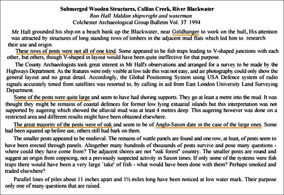
and this 1994 paper
summarises a talk given by Ron Hall about the large and small ancient posts
he indentified in the Blackwater near Goldhanger...
|
|||||||||
|
from...
https://www.british-history.ac.uk/rchme/essex/vol3/pp105-107 An Inventory
of the Historical Monuments in Essex, Volume 3, North East. Originally published by His Majesty's
Stationery Office, London, 1922. GOLDHANGER Goldhanger is a village and parish on
the N. side of the Blackwater estuary and 3½ m. E.N.E. of Maldon. During the
excavation of a Red Hill in 1908 and 1909 near the outlet of the creek, in
the northern part of Fish Pit Marsh, evidence of the intrusion of a Romano-British
settler was disclosed. Below the extreme eastern edge of the
red earth on the old salting surface was found a kitchen midden of
considerable size, containing masses of oyster and mussel shells, animal
bones, many of which had been cut and split, and Roman pottery, including
"large jars with a heavy roll rim." Over this had been spread red
earth from the mound on the west side, and over this again was a layer of
brown mould. In the red earth and mould of the mound had been built some
seven flues, and three or four fire-floors filled with Roman pottery. The flues were chiefly in parallel
pairs, and were from 18 to 30 in. wide, 2 ft. deep and from 5 to 8 ft. long.
They were carefully made and lined with puddled clay about an inch thick and
were filled with black ash and burnt clay. Some of the flues were laid on the
floors, some below them. The floors consisted of hard material burnt yellow,
and from 1 to 3½ ft. in thickness, and measured from 9 ft. by 13 ft. to 12
ft. by 18 ft. 'Samian'
and other ware, bones of domestic animals and shells were abundant in and
about the flues, but details of the smaller finds are lacking, and the date
of the occupation cannot be fixed. It was the opinion of the excavators
that while the Red Hill itself had been built on the open marsh, the mould could
only have formed after the sea-wall had been constructed. Hence they would
assign a pre-Roman
date to the Hill itself, and conjecture the seawall to have been built
possibly in Roman times. The Roman occupation of a Red Hill, of which
this is the only recorded instance, may possibly have been due to a
recrudescence of the industry - whatever it may have been - with which the
original formation of the Red Hill was connected. NOTE: The walls of St. Peter Church
in Goldhanger are of coursed flint-rubble and limestone, with of Roman brick
dressings. The Chancel has E. quoins of Roman brick. |
|
||||||||
|
|
|||||||||
|
A study on this website of
Past local highways and byways also indicates that
the village may once have been on a significant north-south Roman road that
would have connected Colchester to Osea Island. There is a map in the Elms Farm Project
Report (260 pages) from the archaeological dig undertaken near the Causway in Maldon
showing known Roman roads in the area and one of those is the Goldhanger Road
from Heybridge to Goldhanger...
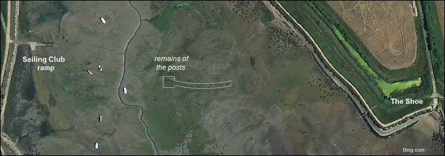
Today posts can be seen on
satellite images in the middle of the Creek between the Sailing Club ramp and
the Shoe... |
|||||||||
|
|
|||||||||
|
_______________ |
|||||||||
|
Much more
recently, with access to the huge amounts of information on the web about the
Roman occupation of Britain, and by looking at how many harbour and ship
remains have been found in the UK, we can perhaps add a little more credence
to Mr Frost’s assement of his finds from Goldhanger Creek... |
|||||||||
|
from... A Maritime Archaeological Research Agenda for England at... https://researchframeworks.org/maritime/roman-c-ad-50-to-400/#section-14
Harbours, ports and landing places: With the
notable exception of London, few remains of Roman harbours and quays have
been identified in Britain. Large numbers of harbours probably existed, as an
island province like Britain was heavily dependent on its sea communications
with the Continent. Their absence in the archaeological record may reflect
the vulnerability of harbour installations to destruction, as a result of
coastal change or continued later use of harbour sites... With the
notable exception of London, comparatively few remains of Roman harbours and
quays have been identified in Britain. Large numbers of harbours probably
existed, as an island province like Britain was heavily dependent on its sea
communications with the Continent. Their absence in the archaeological record
may reflect the vulnerability of harbour installations to destruction, as a
result of coastal change or continued later use of harbour sites... Beginning
around AD c 225, the early forts (Reculver, Brancaster, Bradwell, and Walton Castle) were constructed... Ships and boats found: Five
vessels from the Roman period have been discovered around the UK: ·
mid-2nd-century Blackfriars ship ·
late 2nd-century New Guy’s House boat ·
c 300 Barland’s Farm boat ·
late 3rd-century County Hall ship ·
St Peter Port ship of similar date |
|||||||||
|
from Facebook...
|
and also from Facebook...
|
||||||||
|
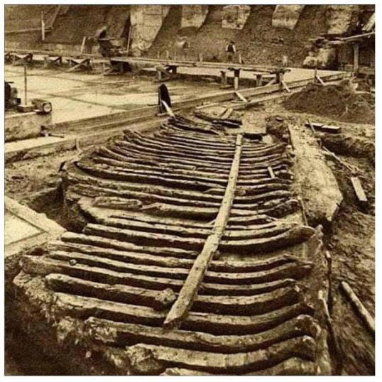
Roman boat - found during the building of County Hall in
London. During the construction of County Hall on the south bank of the
Thames in 1910, workers discovered the wreck of an ancient ship embedded in
the silt. Constructed
from English oak in the third century in a Roman style, the ship dated back
to the era when London was known as the Roman colony of Londinium. The ship
was extracted from the river intact using a large wooden crane. The London
Museum acquired the wreck and exhibited it until the 1930s. Parts of it are
believed to still be in the possession of the Museum of London, the successor
to the London Museum. |
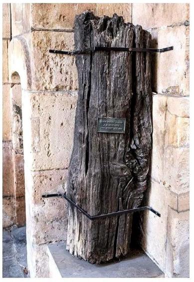
Roman Wharf Piling - located within the porch entry beneath the bell
tower of St Magnus the Martyr Church, London, stands an actual pile from the
Roman period. This part
of the ancient Roman riverside wall was unearthed at Fish Street Hill in 1931
during foundation excavations for a nearby building. Wood sampling has dated
this pile to around 75 AD. |
||||||||
|
it seems remarkably little else has been found to
date _______________ |
|||||||||
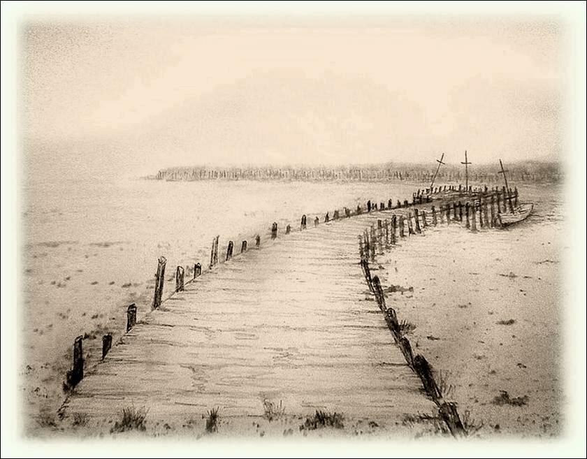
|
From all this accumulated evidence
it is reasonable to assume that there was once a substantial wooden jetty in
the Creek, and may well have been of Roman origin. It would have been
repaired and rebuilt many time since then, and been used by the village
fishing fleet between the 13th and 19th centuries. Today we can only envisage
what that jetty might have looked like in those earlier times... |
|||||||||
|
artist's impression of the
ancient jetty DWN 2024 |
|||||||||
|
|
|||||||||