|
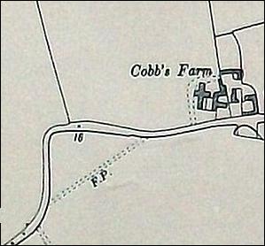
Local highways and byways from the past One can easily wonder why there are so many right-angle bends on the main roads surrounding the village, such as at Cobbs Farm, Wash Lane bridge, Rectory Corner, and on the Lt Totham road near Follyfaunts and at Bakers Green. Today, answers can be found through a study of the local maps from the past and satellite images now available on the internet which show field boundaries and crop marks in great detail. The phenomena is not unique to this parish however and three explanations are given: For the first explanation one has to go back to the time of Domesday Book when the village was just emerging and had 33 householders, it would have been surrounded by woods and uncultivated heath land. The first tracks to be developed would have been the most direct routes across high ground to the nearest towns and villages, ie Maldon, Lt & Gt Totham, Tolleshunt Darcy and Tolleshunt Major. However, when the Romans occupied Britain they introduced the efficient rectangular patchwork of fields with boundaries predominantly north/south - east/west alignments. Farmers would have been motivated to plough the fields in alignment with the boundaries and this encouraged, or compelled, travellers, who had previously used tracks that crossed fields diagonally, to use the headlands and make turns in the corners of the field. In the days when travellers used a horse and cart or walked, it had little consequence, knowing that they were passing over private land. This explanation is probably relevant to the Cobbs Farm bend....
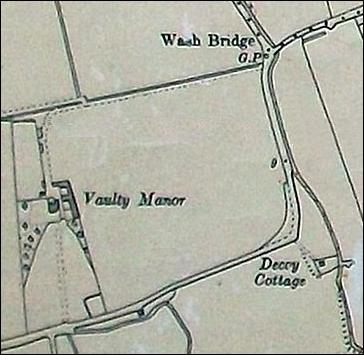
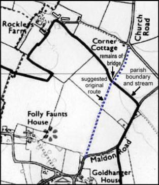
The second reason relates to need for travellers to cross streams using fords in the days well before bridges existed in this area. In the winter, and in periods of high rainfall, when streams were high, the banks either side of a ford would become so muddy and broken up that it would have been difficult if not impossible to cross in a horse and cart. Without any forewarning of an impassable ford the traveller would be then been obliged to divert along the side of the stream to find another crossing. This is probably explains the two sharp bends at Wash Bridge, and to the sharp bend near Corner Cottage in Church Rd between Goldhanger and Tolleshunt Major...
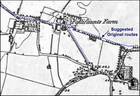
The third reason is associated to the emergent prosperity of farmers and the inclination of wealthy families to purchase remote farmhouses as country residences. Early maps show that many of the established routes passed close to farmhouses and through their farmyards. This was probably because farmers always needed to cart their produce to market and were a major user of the routes. Also they had the ponds where passing horses could drink Once wealthy families were in residence they would not have been comfortable with the ever increasing through traffic and would have been motivated to re-direct the traffic away from their houses and front doors, and around the edge of their fields and land, thus creating sharp corners. This explanation may apply to the bends on the Lt Totham road close to Follyfaunts. In A History of Folly Faunts House author Peter Bushell describes Follyfaunts as a farmhouse that became a Manorial Manor and for many years has been a fine country residence...
|
|||
|
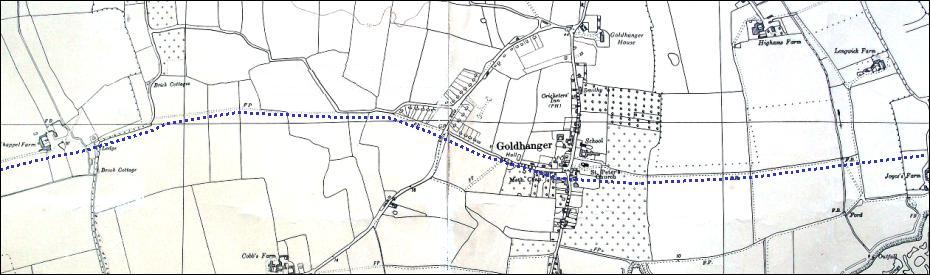
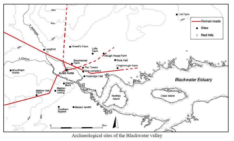
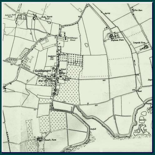
Identifying alternative routes in and around the village It has become clear during this investigation that, as well as identifying the origins of notorious bends in the parish, information from local maps and satellite images can also be used to recognize a number of significant alternative routes through and around the village that almost certainly existed at some time in the past. From local archaeological evidence and an Historic Settlement Assessment study we know that the north bank of the Blackwater Estuary close to the village has been occupied for thousands of years. Census returns tell us how the population of the village has progressively grown over 1000 years and we have available in the Maura Benham book an assessment of The Choice of the Site for the village, together with her assessment of The Shape of the Village in the middle ages. Undoubtedly the network of local highways and byways at various times in the past would have been very different to those today and to those shown on the published maps of the last 300 years. Local authority maintained tarmac roads have only existed since the early 1900s, Dr Salter recorded in his diary that tarmac was first laid through the centre of Tolleshunt Darcy in 1905. Before that time there would have been little difference between public highways, village streets, farm tracks, and footpaths, which would have all had gravel surfaces at best. The east-west orientation of the Blackwater Estuary resulted in local highways and byways fitting broadly into two distinct sets: the predominantly east-west routes used by travellers to reach Maldon, Heybridge, Tolleshunt Darcy and Tollesbury, avoiding the salt marshes along the Estuary; and north-south routes that principally gave access to the Estuary from the inland villages of Lt & Gt Totham, Tolleshunt Major and Tiptree. For centuries these villages have had rights of access to the Estuary which is still enshrined in parish boundaries and shown on some maps These north/south routes are evidence of the importance of sea and river transport in the past. Perversely the north-south routes would also have been valuable to smugglers, whereas the east-west routes would more likely to have been used by the coastguards passing between the various coastguard stations on the north bank of the estuary, and by their forerunners the Riding Officers who would have been based at or near the long-established Maldon Customs House on Market Hill. Both the primary east-west and the north-south highways undoubtedly had Roman origins. See routes 3 & 6 below. |
|||
|
East-west routes 1.
incorporating Head St On page 16 of her book Maura Benham wrote. . . Head Street narrows beyond the Village
Hall and there is reason to think this further stretch has not always been
thought of as Head Street... The map suggests it led straight across to Blind
Lane on what is now a footpath. From a study of
former street names within the village, and
particularly the 1841, census we know Head St was earlier known as Chaple
Street. This is consistent with the Maura Benham theory, and from 1838 map we can see that the track continues
directly to Chappel Farm and passed a former non-conformist Chapel
on Wash Lane. The track
goes on from there to Rook Hall, and footpaths field boundaries indicate a link
directly to Scraley Rd at Heybridge. This would have been a significant
in-land route to Maldon and Beeleigh Abbey in the past (Beeleigh Abbey owned
much of the land around Goldhanger before the Reformation). At high tide and
in the winter this route would avoid the low lying marsh land east of Barrow Marsh Farm that is shown on a 1730s
map. The existing
footpath going through the churchyard across fields to Joyces Farm, which is
marked on many old maps, could be seen an extension of Head St to the east.
From Joyces Farm the track continues to Laurestons Farm and on towards
Tollesbury, thus representing a continuous route from Tollesbury through the
centre of Goldhanger to Maldon. Together with route 9 below, this would have
positioned the village square, St Peters Church
and the Chequers Inn at the junction of a major
north-south/east-west crossroads. . .
2.
incorporating the Maldon Rd Maura Benham identified that the Maldon Rd as we know it today probably was not always a complete east west route. On page 16 of her book she wrote. . . The Maldon Road is now well used and
forms a by-pass for the older part of the village, and maps of the 18th and
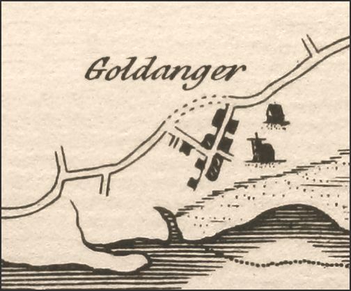
early 19th centuries show it as a road, though a sketch map in Morant's
History of Essex (1768) marks it only in dotted lines . . . Head Street
narrows beyond the Village Hall. . . Striking to the left (west) at the field
entrance beyond the old cottage almost opposite the Village Hall was a
footpath that crossed the field to the point where the road from Maldon bends
awkwardly to the north.
from a Philip Morant map of
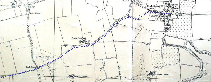
1768 Proceeding further west along the Maldon Rd towards Heybridge more changes to the route can be deduced. The sharp bend at Cobbs Farm has already been mentioned above and there is still a marked footpath cutting the corner off clearly show on 1895 & 1960s maps. The road then reaches Wash Brook and undoubtedly went straight on along an existing footpath to the north of Vaulty Manor and Barrow Marsh Farm to re-join the existing road at the junction with Chigborough Lane. . .
3. incorporating the footpath
through the playing field The footpath alongside the
playing Field at the bottom of Fish St appear on most of the old maps and
could once have been a major east-west route running close to the estuary
heading to Joyces Farm. The same path also goes west and the kinks in the
path today are probably the result of Explanation-2 above. The track joins
the Maldon Rd. at Cobbs Farm,. . .
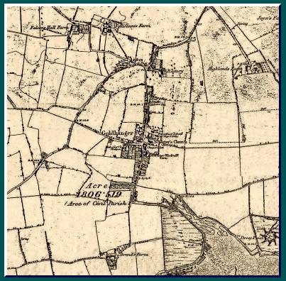
There is a map in the Elms Farm Project Report (260 pages) from the archaeological dig undertaken near the Causway in Maldon showing known Roman roads in the area and one of those is the Goldhanger Road from Heybridge to Goldhanger...
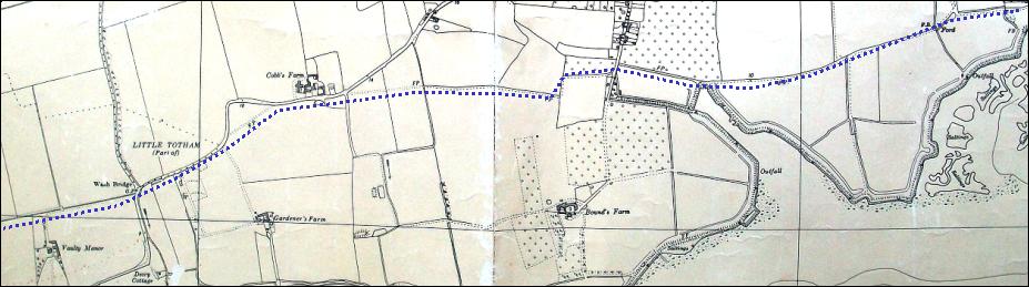
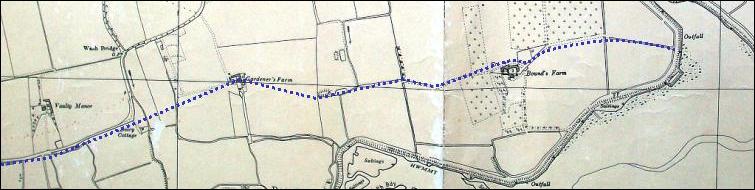
4. incorporating Bounds Farm
east-west footpath There is evidence of a
track on several maps that went east from the former saltworks
(now site of the Sailing Club), the fish pits
(fresh fish would have carted away from here) and the Coastguard Hut, all at the mouth of the
creek, passing just north of Bounds Farm and
on to Gardeners Farm. It would have crossed Wash Brook at the site of a
former Decoy Cottage and connected with the Maldon Rd, passing south of
Vaulty Manor and on to Heybridge and Maldon. Before the final section of seawall was built in the early 1800s at high
tide the salt marsh areas between Barrow Marsh Farm and the Saltcote saltworks would have made this route impassable . . .
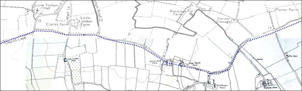
5. incorporating Rectory corner
going west All the local
maps between 1880 and 1960 show a distinct field boundary going east from
Rectory Corner (20yds from Rectory Cottage) which could have been a
continuation of the Maldon Rd from Darcy running east through the Follyfaunts
estate, and passing very close to the front of the farmhouse. It then joins
the Lt Totham Rd near Falcons Hall. At the sharp right hand corner at Bakers
Green a footpath continues straight on west and links with Church Lane, Gt
Totham and continues to Gt Totham Church. . .
|
|||
|
North-south
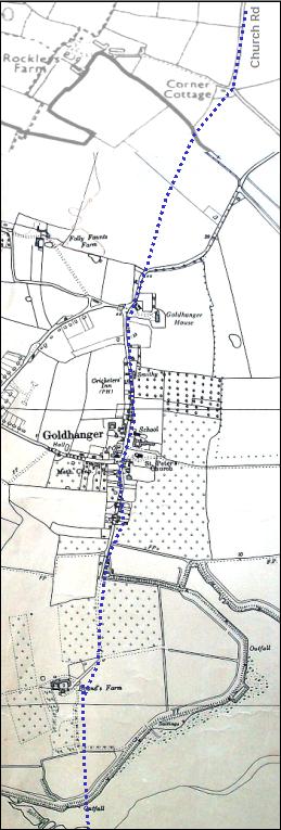
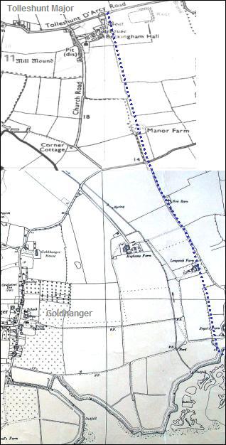
routes 6. North and
south through The Square Church Street heads directly north from The Square, joins the Maldon Rd, and continues north for just 100 yds before turning sharply right at Rectory Corner towards Tolleshunt Darcy. If however the road continued straight on north at this point it would join up with Church Road in Tolleshunt Major parish. A Goldhanger resident remembered there being the remains of a bridge over the stream on this missing link. At the north end of Church Lane the road passes the front gatehouse of Beckingham Hall and at the juction with Beckingham Road there a hedgerow continuing north which is aligned with Tudwick Road which takes one on to Tiptree and the Roman road between Heybridge and Colchester. Running directly south
from The Square down Fish Street and through Bounds Farm one arrives at the
seawall and Bounds Hatches. Barges
once used to tie up here on the hardstanding to load and unload, and there is
also evidence of a track leading across the estuary toward Osea Island. This
track would have passed across The Stumble which from archaeological evidence shows it was occupied in
the Neolithic period, and is shown as an small island on a map as recently as
1924. Thus a direct north-south highway from Tiptree to Osea Island can be
identified that passed straight through the centre of the village. Records of past street names tell us that as recently as the 1870s
Church St and Fish St were both called The
Street, and we know that villages with a north-south or east-west road
called The Street the name is
usually of Roman origin. Together
with route 1 above, this would have positioned the village square and the The Chequers Inn at the junction of a major
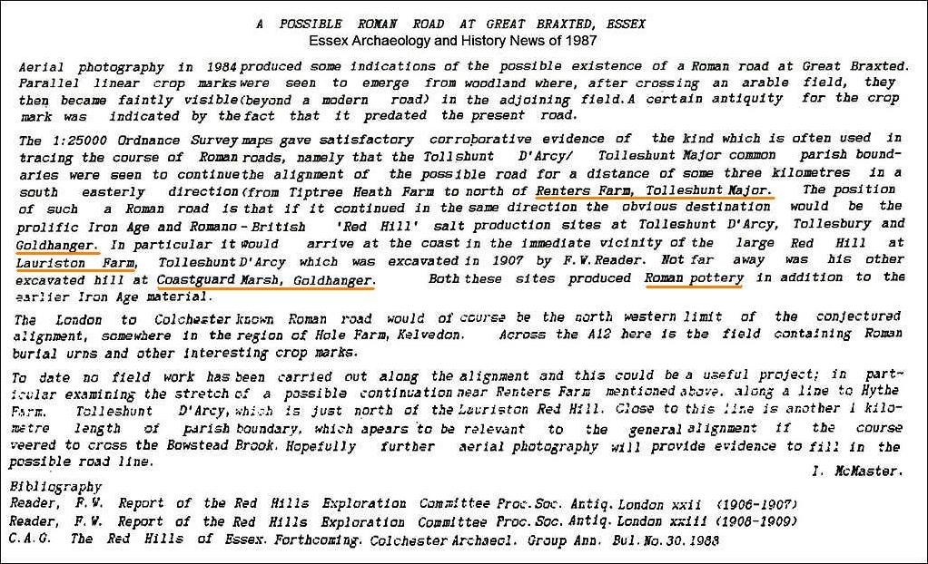
north-south/east-west crossroads. See this document: "Possible Roman Rd" and... Posts in the Creek with significant Roman connections. 7. Tolleshunt Major to the seawall via Joyces Chase There is evidence on old
maps of a track from Beckingham Hall and through Beckingham Farm, that joins an
existing farm track past the former Manor Farm, and joins Joyces Chase to
reach the seawall at Joyces Farm. There is a similar route from the Maldon Rd
along Highams Chase, through Highams Farm on existing farm tracks, past the
former decoy cottage and Decoy Ponds, ending at
the seawall and The Shoe. Barges once used to tie up here on the
hardstanding to load and unload. Huge numbers of wildfowl were said to have
been caught and transported to markets by the horse and cart from the decoy
ponds. The route would also have exploited the Tolleshunt Major ancient right
access to the estuary and this isolated route would have been used by smugglers. 8.
Little Totham Hall to Osea Island On the 1960s map there is evidence of a track that
follows the course of Wash Brook from Little Totham Hall, passing
close to Chappel Farm and from there along Wash Lane to Wash Bridge. The
route then joins a short section of the Maldon Rd to where there was a decoy
cottage (shown on the 1960s map). From
there it is just a short distance to the Decoy Ponds,
Osea Rd, and Osea Island causeway. Wash Lane and Wash Bridge was probably the
location of a watermill that had an
address of Goldhanger in the 1840s, which would make this an important
north-south route and would have exploited the Little Totham ancient right of
access to the estuary and also would have
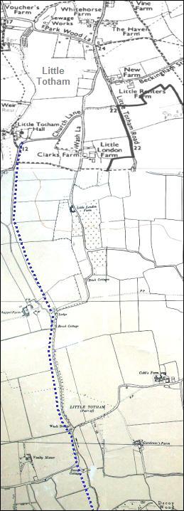
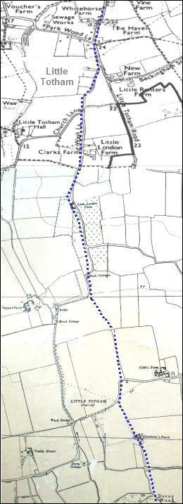
been used by smugglers. . 9. Little Totham village to Decoy Point Present day roads extend
directly south from the village of Little Totham along Chappel Rd, past Clarks
Farm and Little London Farm, to the former non-conformist Chapel at Brick Cottage the road then bears to
the right. However, a field boundary shown on the maps indicated that a track
could have continued directly south to the Cobbs Farm bend, then on through
Gardeners Farm and to the seawall at Decoy Point. This route would
also have exploited the Little Totham right of access to the estuary and
again would have been used by smugglers. . |
Route 6
|
||
|
Route 7
|
|||
|
Route 8
|
|||
|
Route 9
|
|||
|
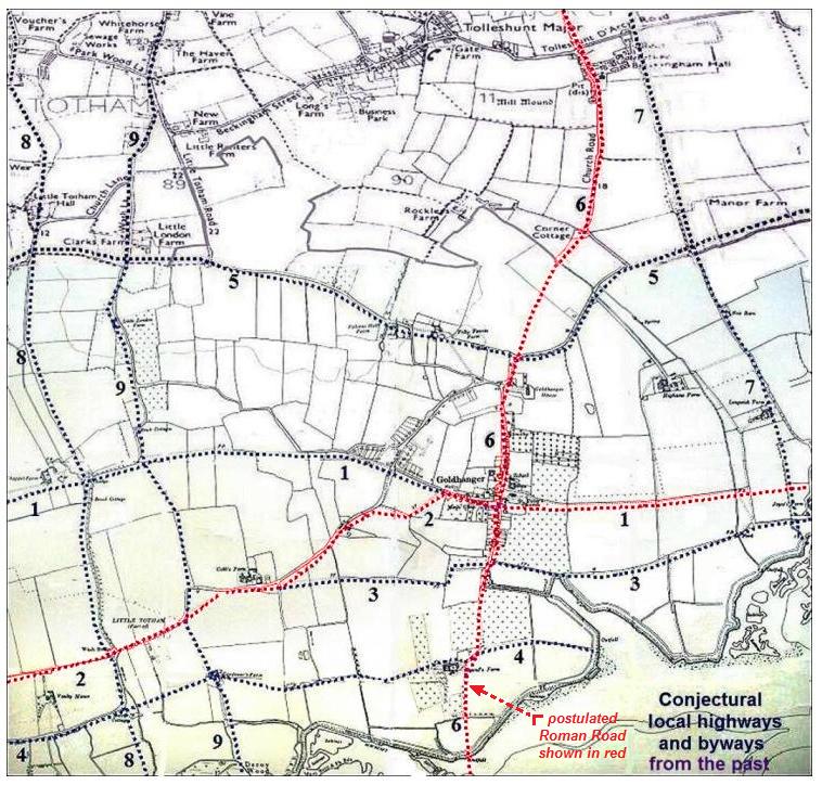
________________________________ the nine ancient routes
identified above are presented here on one conjectural map with the postulated Roman
routes shown in red...
select the map to enlarge
and zoom in |
|||